
Monday/Tuesday May 10/11
Page 1 of 2 • 1, 2 ![]()

Monday/Tuesday May 10/11
![]() Stormman Wed May 05, 2010 8:26 pm
Stormman Wed May 05, 2010 8:26 pm

First look at a another system that could play a role in another round of severe t storms.
Stormman- Posts : 85
Join date : 2010-01-06
Age : 35
Location : Springfield,Mo
Re: Monday/Tuesday May 10/11
![]() harm63 Thu May 06, 2010 1:48 pm
harm63 Thu May 06, 2010 1:48 pm

harm63- Posts : 12
Join date : 2010-01-06
Age : 41
Location : Springfield, MO
Re: Monday/Tuesday May 10/11
![]() Mindi Fri May 07, 2010 12:30 pm
Mindi Fri May 07, 2010 12:30 pm

Mindi- Posts : 35
Join date : 2010-01-04
Age : 51
Re: Monday/Tuesday May 10/11
![]() harm63 Fri May 07, 2010 4:32 pm
harm63 Fri May 07, 2010 4:32 pm
harm63- Posts : 12
Join date : 2010-01-06
Age : 41
Location : Springfield, MO
Re: Monday/Tuesday May 10/11
![]() Gary_Monett Fri May 07, 2010 9:04 pm
Gary_Monett Fri May 07, 2010 9:04 pm

Gary_Monett- Posts : 124
Join date : 2010-01-04
Re: Monday/Tuesday May 10/11
![]() Gary_Monett Sat May 08, 2010 11:18 am
Gary_Monett Sat May 08, 2010 11:18 am
Gary_Monett- Posts : 124
Join date : 2010-01-04
Re: Monday/Tuesday May 10/11
![]() Mindi Sat May 08, 2010 11:20 am
Mindi Sat May 08, 2010 11:20 am
Mindi- Posts : 35
Join date : 2010-01-04
Age : 51
Re: Monday/Tuesday May 10/11
![]() Gary_Monett Sat May 08, 2010 11:23 am
Gary_Monett Sat May 08, 2010 11:23 am
Gary_Monett- Posts : 124
Join date : 2010-01-04
Re: Monday/Tuesday May 10/11
![]() Gary_Monett Sun May 09, 2010 6:35 am
Gary_Monett Sun May 09, 2010 6:35 am
***SUPERCELLS WITH LONG-TRACK STRONG TORNADOES AND VERY LARGE HAIL
EXPECTED MONDAY LATE AFTN/EVENING ACROSS PARTS OF CNTRL/N OK...SE KS
AND SW MO***
That is from the Storm Prediction Center.
Gary_Monett- Posts : 124
Join date : 2010-01-04
Re: Monday/Tuesday May 10/11
![]() Mindi Sun May 09, 2010 7:33 am
Mindi Sun May 09, 2010 7:33 am
Mindi- Posts : 35
Join date : 2010-01-04
Age : 51
Re: Monday/Tuesday May 10/11
![]() weatherplus Sun May 09, 2010 8:24 am
weatherplus Sun May 09, 2010 8:24 am
weatherplus- Posts : 106
Join date : 2010-01-26
Re: Monday/Tuesday May 10/11
![]() weatherplus Sun May 09, 2010 2:30 pm
weatherplus Sun May 09, 2010 2:30 pm
http://www.crh.noaa.gov/sgf/?n=dec_sup_svrstorm_day2
weatherplus- Posts : 106
Join date : 2010-01-26
Re: Monday/Tuesday May 10/11
![]() Craazy Sun May 09, 2010 3:43 pm
Craazy Sun May 09, 2010 3:43 pm
Craazy- Posts : 1
Join date : 2010-05-09
Re: Monday/Tuesday May 10/11
![]() Gary_Monett Sun May 09, 2010 5:05 pm
Gary_Monett Sun May 09, 2010 5:05 pm
www.kspr.com/weather/chat
Gary_Monett- Posts : 124
Join date : 2010-01-04
Re: Monday/Tuesday May 10/11
![]() harm63 Sun May 09, 2010 5:38 pm
harm63 Sun May 09, 2010 5:38 pm

harm63- Posts : 12
Join date : 2010-01-06
Age : 41
Location : Springfield, MO
Re: Monday/Tuesday May 10/11
![]() weatherplus Sun May 09, 2010 5:47 pm
weatherplus Sun May 09, 2010 5:47 pm
weatherplus- Posts : 106
Join date : 2010-01-26
Re: Monday/Tuesday May 10/11
![]() harm63 Sun May 09, 2010 5:53 pm
harm63 Sun May 09, 2010 5:53 pm
......startin' to get excited....
Looks like Dr. Forbes' TOR-CON index for tomorrow is 8/10 for eastern KS if that's indication for us...
harm63- Posts : 12
Join date : 2010-01-06
Age : 41
Location : Springfield, MO
Re: Monday/Tuesday May 10/11
![]() Stormman Sun May 09, 2010 8:48 pm
Stormman Sun May 09, 2010 8:48 pm
Significant tornado parameters look to be coming together tomorrow evening across the entire outlook area, the NWS has the area in an EXTREME risk for severe weather with mentioning of long track tornadoes. The ingredients do look to come together tomorrw, it's gonna be a DANGEROUS setup and everyone needs to stay alert and have your weather radios on! I will be in the field chasing tomorrow, I would like to know how many will be out tomorrow, maybe we can meet in Joplin. The cold front will not make it all the way through the Ozarks until sometime during the day Tuesday, then lift North again as a warm front Wednesday, the timing of all this is tricky but there could be another round Wednesday.
Stormman- Posts : 85
Join date : 2010-01-06
Age : 35
Location : Springfield,Mo
Re: Monday/Tuesday May 10/11
![]() PaigeNicole Sun May 09, 2010 11:29 pm
PaigeNicole Sun May 09, 2010 11:29 pm
(Mindi has my number or you can email me at me@ p a i g enicole photography.com (it goes to my phone)
I'll be bored all day, til the storms get here...then I'll be near my storm room <3 hahaha.

PaigeNicole- Posts : 4
Join date : 2010-01-04
Location : Joplin, MO
Re: Monday/Tuesday May 10/11
![]() weatherplus Mon May 10, 2010 6:05 am
weatherplus Mon May 10, 2010 6:05 am
weatherplus- Posts : 106
Join date : 2010-01-26
Re: Monday/Tuesday May 10/11
![]() Gary_Monett Mon May 10, 2010 6:24 am
Gary_Monett Mon May 10, 2010 6:24 am
If the instability isn't realized, then SW MO won't have nearly as much to worry about. Time to wait and see at this point.
Gary_Monett- Posts : 124
Join date : 2010-01-04
Re: Monday/Tuesday May 10/11
![]() harm63 Mon May 10, 2010 11:47 am
harm63 Mon May 10, 2010 11:47 am
It is interesting to listen to the discussions, etc that the NWS is having right now. Not very often to hear them be this serious about a given weather situation.
harm63- Posts : 12
Join date : 2010-01-06
Age : 41
Location : Springfield, MO
Re: Monday/Tuesday May 10/11
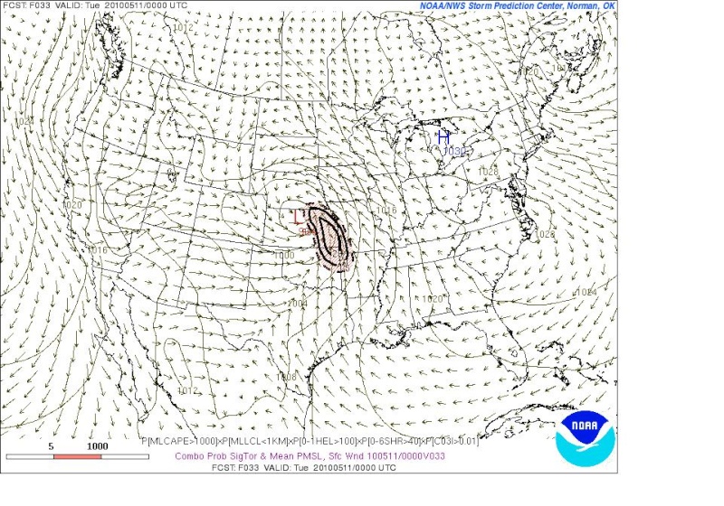
![]() Stormman Mon May 10, 2010 2:25 pm
Stormman Mon May 10, 2010 2:25 pm
Stormman- Posts : 85
Join date : 2010-01-06
Age : 35
Location : Springfield,Mo
Re: Monday/Tuesday May 10/11
![]() MichaelD Mon May 10, 2010 3:44 pm
MichaelD Mon May 10, 2010 3:44 pm

MichaelD- Posts : 20
Join date : 2010-01-05
Re: Monday/Tuesday May 10/11
![]() MichaelD Mon May 10, 2010 11:04 pm
MichaelD Mon May 10, 2010 11:04 pm
MichaelD- Posts : 20
Join date : 2010-01-05
Page 1 of 2 • 1, 2 ![]()
» Tuesday June 8
» Tuesday April 19
» Severe Storms Possible on Tuesday March 22
» Monday March 8th
|
|
|