
Thursday May 20th
Page 1 of 1

Thursday May 20th
![]() Stormman Thu May 20, 2010 10:36 am
Stormman Thu May 20, 2010 10:36 am
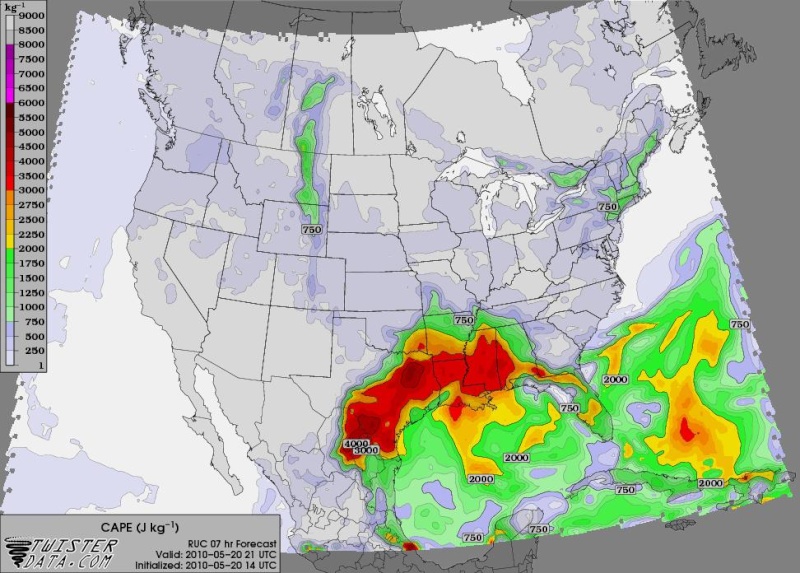
Conditions may come together later today for the development of supercell thunderstorms as the area of upper energy out West sends the warm front into SW MO and creates a narrow warm sector. Latest RUC below depicts the narrow band of moderate instability.
D. Forbes from the weather channel gives SW MO a 5 on the Tor Con index, rather high IMO, but not out of the relm of possibility. Looking down the pipe, the next meaningful upper trough doesn't make it into the Central Plains until June 1/2.
D. Forbes from the weather channel gives SW MO a 5 on the Tor Con index, rather high IMO, but not out of the relm of possibility. Looking down the pipe, the next meaningful upper trough doesn't make it into the Central Plains until June 1/2.
Stormman- Posts : 85
Join date : 2010-01-06
Age : 35
Location : Springfield,Mo
Re: Thursday May 20th
![]() Stormman Thu May 20, 2010 10:40 am
Stormman Thu May 20, 2010 10:40 am
Though yes the chance for some severe storms is there today, the main threats will be large hail and flash flooding as the ground is VERY saturated, it won't take much to get the local streams and rivers to begin rising.
Stormman- Posts : 85
Join date : 2010-01-06
Age : 35
Location : Springfield,Mo
» Thursday April 14
» January 6th and 7th Snowfall Event
» Thursday, February 4
» Thursday, January 28th
» January 6th and 7th Snowfall Event
» Thursday, February 4
» Thursday, January 28th
Page 1 of 1
Permissions in this forum:
You cannot reply to topics in this forum|
|
|