
Monday/Tuesday Feb. 8/9
Page 2 of 6 •  1, 2, 3, 4, 5, 6
 ![]()
Re: Monday/Tuesday Feb. 8/9
![]() Greatness Fri Feb 05, 2010 10:09 am
Greatness Fri Feb 05, 2010 10:09 am
Greatness- Posts : 15
Join date : 2010-01-04
Re: Monday/Tuesday Feb. 8/9
![]() weatherplus Fri Feb 05, 2010 10:14 am
weatherplus Fri Feb 05, 2010 10:14 am
Last edited by weatherplus on Fri Feb 05, 2010 11:01 am; edited 1 time in total
weatherplus- Posts : 106
Join date : 2010-01-26
Re: Monday/Tuesday Feb. 8/9
![]() Stormman Fri Feb 05, 2010 10:22 am
Stormman Fri Feb 05, 2010 10:22 am
Stormman- Posts : 85
Join date : 2010-01-06
Age : 35
Location : Springfield,Mo
Re: Monday/Tuesday Feb. 8/9
![]() Greatness Fri Feb 05, 2010 12:21 pm
Greatness Fri Feb 05, 2010 12:21 pm
Greatness- Posts : 15
Join date : 2010-01-04
Re: Monday/Tuesday Feb. 8/9
![]() KSPR Craig Carnesi Fri Feb 05, 2010 12:51 pm
KSPR Craig Carnesi Fri Feb 05, 2010 12:51 pm
Here are the latest snow total models from the 12z run Friday.
First the NAM:

And the GFS:

KSPR Craig Carnesi- Posts : 37
Join date : 2009-12-31
Location : Springfield, MO -

Re: Monday/Tuesday Feb. 8/9
![]() weatherplus Fri Feb 05, 2010 2:39 pm
weatherplus Fri Feb 05, 2010 2:39 pm
weatherplus- Posts : 106
Join date : 2010-01-26
Re: Monday/Tuesday Feb. 8/9
![]() weloveourhailey Fri Feb 05, 2010 3:19 pm
weloveourhailey Fri Feb 05, 2010 3:19 pm
weloveourhailey- Posts : 86
Join date : 2010-01-05
Re: Monday/Tuesday Feb. 8/9
![]() weather37 Fri Feb 05, 2010 3:24 pm
weather37 Fri Feb 05, 2010 3:24 pm
weather37- Posts : 19
Join date : 2010-01-04
Re: Monday/Tuesday Feb. 8/9
![]() Greatness Fri Feb 05, 2010 3:51 pm
Greatness Fri Feb 05, 2010 3:51 pm
Greatness- Posts : 15
Join date : 2010-01-04
Re: Monday/Tuesday Feb. 8/9
![]() Breckenridge150 Fri Feb 05, 2010 4:42 pm
Breckenridge150 Fri Feb 05, 2010 4:42 pm
Breckenridge150- Posts : 8
Join date : 2010-01-18
Re: Monday/Tuesday Feb. 8/9
![]() Gary_Monett Fri Feb 05, 2010 5:10 pm
Gary_Monett Fri Feb 05, 2010 5:10 pm
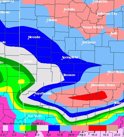
SNOW WILL LIKELY DEVELOP OVER EASTERN KANSAS AND WESTERN MISSOURI
BY LATE SUNDAY AFTERNOON THEN OVERSPREAD THE MISSOURI OZARKS
SUNDAY NIGHT. SNOW WILL CONTINUE MONDAY BEFORE ENDING LATE MONDAY
NIGHT. THE SNOW MAY BECOME MIXED WITH OR CHANGE TO RAIN AND SLEET
ON MONDAY ACROSS SOUTHERN MISSOURI AND EXTREME SOUTHEAST KANSAS. THIS
WILL SIGNIFICANTLY IMPACT SNOW ACCUMULATIONS IF AND WHEN THIS
OCCURS.

Gary_Monett- Posts : 124
Join date : 2010-01-04
Re: Monday/Tuesday Feb. 8/9
![]() weatherplus Fri Feb 05, 2010 6:44 pm
weatherplus Fri Feb 05, 2010 6:44 pm
http://www.hpc.ncep.noaa.gov/wwd/day3_psnow_gt_04.gif
http://www.hpc.ncep.noaa.gov/wwd/day3_psnow_gt_08.gif
http://www.hpc.ncep.noaa.gov/qpf/fill_99qwbg.gif
weatherplus- Posts : 106
Join date : 2010-01-26
Re: Monday/Tuesday Feb. 8/9
![]() Gary_Monett Fri Feb 05, 2010 9:24 pm
Gary_Monett Fri Feb 05, 2010 9:24 pm

Gary_Monett- Posts : 124
Join date : 2010-01-04
Re: Monday/Tuesday Feb. 8/9
![]() weloveourhailey Fri Feb 05, 2010 9:36 pm
weloveourhailey Fri Feb 05, 2010 9:36 pm
weloveourhailey- Posts : 86
Join date : 2010-01-05
Re: Monday/Tuesday Feb. 8/9
![]() Gary_Monett Fri Feb 05, 2010 10:02 pm
Gary_Monett Fri Feb 05, 2010 10:02 pm
weloveourhailey wrote:I think its going to be mostly a cold rain event I hope im wrong
Latest NAM model is colder and, as a result, snowier for this system.

Gary_Monett- Posts : 124
Join date : 2010-01-04
Re: Monday/Tuesday Feb. 8/9
![]() KSPR Craig Carnesi Fri Feb 05, 2010 10:11 pm
KSPR Craig Carnesi Fri Feb 05, 2010 10:11 pm
KSPR Craig Carnesi- Posts : 37
Join date : 2009-12-31
Location : Springfield, MO -
Re: Monday/Tuesday Feb. 8/9
![]() KSPR Craig Carnesi Fri Feb 05, 2010 11:11 pm
KSPR Craig Carnesi Fri Feb 05, 2010 11:11 pm
Again, don't go buy all of the bread and milk at the store just yet... Let's give it another day of model runs and check back here through the day Saturday.
No matter how much snow we get, we are going to deal with another significant winter storm Sunday night and through the day Monday.

KSPR Craig Carnesi- Posts : 37
Join date : 2009-12-31
Location : Springfield, MO -
Re: Monday/Tuesday Feb. 8/9
![]() weloveourhailey Fri Feb 05, 2010 11:39 pm
weloveourhailey Fri Feb 05, 2010 11:39 pm
weloveourhailey- Posts : 86
Join date : 2010-01-05
Re: Monday/Tuesday Feb. 8/9
![]() KSPR Craig Carnesi Fri Feb 05, 2010 11:42 pm
KSPR Craig Carnesi Fri Feb 05, 2010 11:42 pm
Good for you for flipping around! I hope you take note of how this system actually pans out and remember which station gets it right!weloveourhailey wrote:Another local station mentioned us just getting mostly rain and areas around kc and lake of the ozarks getting a ton of snow.
KSPR Craig Carnesi- Posts : 37
Join date : 2009-12-31
Location : Springfield, MO -
Re: Monday/Tuesday Feb. 8/9
![]() reality_007 Fri Feb 05, 2010 11:45 pm
reality_007 Fri Feb 05, 2010 11:45 pm
KSPR Craig Carnesi wrote:Good for you for flipping around! I hope you take note of how this system actually pans out and remember which station gets it right!weloveourhailey wrote:Another local station mentioned us just getting mostly rain and areas around kc and lake of the ozarks getting a ton of snow.
Love it and I love KSPR! Only place I turn to for weather.

reality_007- Posts : 21
Join date : 2010-01-28
Age : 35
Location : Springfield, MO
Re: Monday/Tuesday Feb. 8/9
![]() Greatness Fri Feb 05, 2010 11:47 pm
Greatness Fri Feb 05, 2010 11:47 pm
Greatness- Posts : 15
Join date : 2010-01-04
Re: Monday/Tuesday Feb. 8/9
![]() NixaDorothy Fri Feb 05, 2010 11:53 pm
NixaDorothy Fri Feb 05, 2010 11:53 pm
NixaDorothy- Posts : 45
Join date : 2010-01-04
Re: Monday/Tuesday Feb. 8/9
![]() weatherplus Fri Feb 05, 2010 11:59 pm
weatherplus Fri Feb 05, 2010 11:59 pm
weatherplus- Posts : 106
Join date : 2010-01-26
Re: Monday/Tuesday Feb. 8/9
![]() jsowers77 Sat Feb 06, 2010 12:00 am
jsowers77 Sat Feb 06, 2010 12:00 am
Maybe it will snow, maybe it will rain, maybe dogs will meow, cats bark, and pigs fly.. Maybe a lot of things might happen, but I rely on the consensus within the scientific community...not stations going for ratings or chicken little. To other stations/posters/everyday folks: You must have great evidence to substantiate a great claim.
jsowers77- Posts : 12
Join date : 2010-01-28
Re: Monday/Tuesday Feb. 8/9
![]() Gary_Monett Sat Feb 06, 2010 6:23 am
Gary_Monett Sat Feb 06, 2010 6:23 am
Gary_Monett- Posts : 124
Join date : 2010-01-04
Page 2 of 6 • 1, 2, 3, 4, 5, 6 ![]()
» Tuesday June 8
» Tuesday April 19
» Severe Storms Possible on Tuesday March 22
» Monday March 8th
|
|
|